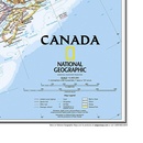
Wandkaart 20527 Canada, 97 x 82 cm | National Geographic (9781597753548)
Papieren versie
- ISBN / CODE: 9781597753548
- Editie: 24-01-2019
- Aantal blz.: 1
- Schaal: 1:6410000
- Uitgever: National Geographic
- Soort: Wandkaart van een land
- Taal: Engels
- Hoogte: 81.0 cm
- Breedte: 97.0 cm
- Gewicht: 216.0 g
- Uitvoering: Papier
- Cartografie: Politiek
- Schrijf als eerste een review
-
€ 28,95
Leverbaar in 3 - 5 werkdagen in huis in Nederland Levertijd Belgie
Gratis verzending in Nederland vanaf €35,-
Beschrijving
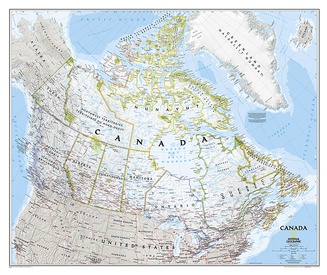
Decoratieve wandkaart van Canada. Naast de mooie kleuren staan er bijzonder veel plaatsen op vermeld.
This beautiful wall-map from National Geographic depicts Canada and the areas surrounding the Great Lakes in beautiful and accurate detail. Included in the map are Canadian province and US State boundaries, cities and towns, lakes and waterways, major geographic features, roadways, and other geographic details.
Our most detailed wall map of Canada, features the classic National Geographic reference styling. Features thousands of place names, accurate political boundaries, national parks, archeological sites, and major infrastructure networks such as roads, canals, ferry routes, and railroads. Canada s diverse terrain is detailed through accurate shaded relief, coastal bathymetry, and symbolism for water features and other landforms. This wall map depicts Canada and the areas surrounding the Great Lakes. Includes Canadian provinces and US State boundaries.
Dit product heeft meerdere varianten:

