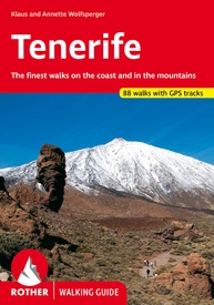
Wandelgids Tenerife (Engelstalig) | Rother Bergverlag (9783763348442)
The finest walks on the coast and in the mountains
- ISBN / CODE: 9783763348442
- Editie: 15-02-2024
- Druk: 8
- Aantal blz.: 303
- Auteur(s): Klaus & Anette Wolfsperger
- Uitgever: Rother Bergverlag
- Soort: Wandelgids
- Serie: Walking guide
- Taal: Engels
- Hoogte: 17.0 cm
- Breedte: 12.0 cm
- Gewicht: 180.0 g
- Uitvoering: -
- Bindwijze: Paperback
- Beoordeling: 3,8 ★★★★★ (4 reviews) Schrijf een review
-
€ 18,50
Levertijd 2 - 4 werkdagen in huis in Nederland Levertijd Belgie
Gratis verzending in Nederland vanaf €35,-
Beschrijving
Uitstekende wandelgids met een groot aantal dagtochten in dal en hooggebergte. Met praktische informatie en beperkt kaartmateriaal! Wandelingen in verschillende zwaarte weergegeven in rood/blauw/zwart.
Reviews
We hebben de gids samen met Tenerife Hikers' Map gebruikt (voor het geval we per ongeluk van de kaartjes van de gids zouden lopen, wat overigens niet gebeurd is). We hebben uiteindelijk 4 "blauwe" (= easy) routes gelopen. Die waren door de rotsige, oneffen ondergrond soms al best zwaar lopen, dus het is niet vergelijkbaar met wandelen in Nederland. In het boekje staan veel langere routes van (>4 uur). Leuke wandelingen en de kaartjes gaven voldoende info. De instructies zijn duidelijk, hoewel het soms pas naarmate je er komt duidelijk wordt wat werd bedoeld. Dus handig is om steeds een stukje vooruit te lezen! De tijdsindicaties zijn voor de wandelaar met een flink tempo ;-). Als je wat vaker stilstaat om te genieten van het landschap en/of uit te rusten moet je er wel wat bij optellen.
★★★★★ door Celine 25 februari 2019Vond u dit een nuttige review? (login om te beoordelen)
Het is een handzaam boekje met goed beschreven wandelingen op Tenerife. De deskundigheid van de schrijvers straalt er van af. Er staan goede waarschuwingen in voor gevaarlijke punten op de routes. Verder alle gegevens zoals startpunt, hoogteverschillen, lengte, zwaarte enz. In de GPS files die je kunt downloaden, staat ook een lijst met beginpunten met GPS locaties. Dat is weer handig voor de TomTom als je naar het beginpunt rijdt. Dus goede aankoop. De enige opmerking is eigenlijk dat het een beetje kleine letters en foto's zijn.
★★★★★ door henk vegter 13 februari 2019Vond u dit een nuttige review? (login om te beoordelen)
Redelijke gids maar ik zou ook aan lokalen de route vragen want de routes alleen met gids is niet altijd te doen.
★★★★★ door paul 21 november 2018Vond u dit een nuttige review? (login om te beoordelen)
Schrijf een review
Graag horen wij wat u van dit artikel vindt. Vindt u het goed, leuk, mooi, slecht, lelijk, onbruikbaar of erg handig: schrijf gerust alles op! Het is niet alleen leuk om te doen maar u informeert andere klanten er ook nog mee!


