Mandje Tel: +31503126950 Menu
Winkelwagen
Geen items in winkelwagen
Ga naar winkelwagen

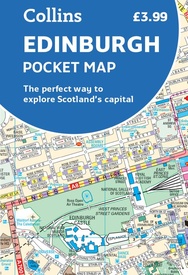
Stadsplattegrond Pocket Map Edinburgh | Collins (9780008663469)

  • ISBN / CODE: 9780008663469
  • Editie: meest recente editie
  • Schaal: 1:11000
  • Uitgever: Collins
  • Soort: Stadsplattegrond
  • Serie: Pocket Map
  • Taal: Engels
  • Bindwijze: -
  • Uitvoering: Papier
  • Schrijf als eerste een review
  • 7,95

    Op voorraad. Binnen 2 - 3 werkdagen in huis in Belgie Levertijd Nederland Voor 17.00 uur op werkdagen besteld, morgen in huis in Nederland Levertijd Belgie

    Gratis verzending in Nederland vanaf €35,-

Beschrijving

Handy little full colour map of central Edinburgh with a high level of detail. Clear mapping from Leith in the north to The Meadows in the south, and Edinburgh Zoo in the west to Holyrood Park in the east. Map at a scale of 1:11,000 (6 inches to 1 mile).
 
Clear, detailed, full colour mapping is presented in a handy format ideal for the pocket or handbag. It is excellent value and covers the most visited area of central Edinburgh. It is an essential buy for tourists and residents alike.
 
This map includes:
• Detailed central area map
• Around Edinburgh map extending to airport, Pentland Hills and Forth Road Bridge
• Tourist locations
• Tram, train and bus stations
• Listing of major places to visit, with additional details for Edinburgh Castle and Holyroodhouse
• Detailed street index

Reviews

Geen reviews gevonden voor dit product.

Schrijf een review

Graag horen wij wat u van dit artikel vindt. Vindt u het goed, leuk, mooi, slecht, lelijk, onbruikbaar of erg handig: schrijf gerust alles op! Het is niet alleen leuk om te doen maar u informeert andere klanten er ook nog mee!