Mandje Tel: +31503126950 Menu
Winkelwagen
Geen items in winkelwagen
Ga naar winkelwagen

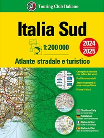
Wegenatlas Atlante Stradale d'Italia Sud | Touring Club Italiano (9788836580927)

Zuid Italie

  • ISBN / CODE: 9788836580927
  • Editie: 27-11-2023
  • Aantal blz.: 168
  • Schaal: 1:200000
  • Uitgever: Touring Club Italiano
  • Soort: Wegenatlas
  • Taal: Engels, Italiaans
  • Hoogte: 32.0 cm
  • Breedte: 24.2 cm
  • Gewicht: 988.0 g
  • Bindwijze: Paperback
  • Uitvoering: Papier
  • Beoordeling: 5,0 ★★★★★ (1 review) Schrijf een review
  • 24,95

    Leverbaar in 3 - 5 werkdagen in huis in Belgie Levertijd Nederland Leverbaar in 3 - 5 werkdagen in huis in Nederland Levertijd Belgie

    Gratis verzending in Nederland vanaf €35,-

Beschrijving

Atlas van de Italiaanse ANWB, goed kaartbeeld. Wel met omgevingskaarten van belangrijke steden en stadsplattegronden. Kaarten vanaf Rome naar het zuiden.

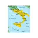
Wegenatlas met gedetaileerde wegenkaarten van zuidelijk Italië, ten zuiden van Rome en met Sicilie, snelwegkaarten met afritten, toeristische informatie, plattegronden van steden, de kaarten zijn ook geschikt om op te fietsen

Southern Italy at 1:200,000 in a series of three excellent road atlases from the Touring Club Italiano, each with enlargements of the environs of main cities, numerous superb indexed street plans, plus a very comprehensive distance table.
 
The atlases are in a paperback format, slightly larger than A4. Cartography is the same as in TCI’s 1:200,000 series of regional maps, with subtle but very effective relief shading plus spot heights to present the topography. Numerous names of mountain ranges, valleys, peaks, etc. are shown and national parks and other protected areas are prominently highlighted.
 
Road network is presented in great detail, from motorways to dirt tracks navigable only with difficulty. Minor roads are very clear and easy to read and, where necessary, are drawn without generalizing their course, showing the twists and turns across the mountainous terrain. Steep roads are annotated with three levels of gradient markings. Motorways have the usual features such as toll barriers, services, etc. Scenic routes are highlighted. Railway network shows stations and level crossings and, where appropriate, ferry routes are marked. In mountainous areas refuges, cable car lines, chair lifts, etc, are included. Towns, villages and other places of particular interest are highlighted, with symbols indicating various monuments, castes, churches, etc. The maps have no geographical co-ordinates. 
 
Each volume includes enlargements at 1:80,000 for environs of main cities, plus numerous superb street plans, each with an index of sights and streets.


Reviews

Goede atlas

Dit zijn goede atlassen, duidelijk te lezen en erg stevig. Ze gaan lang mee. Wij hebben van alle delen van Italië deze atlassen, al zeker 10 jaar.

★★★★★ door Kees de Korte 24 juni 2019

Vond u dit een nuttige review? (login om te beoordelen)

-
Nee (0)

Schrijf een review

Graag horen wij wat u van dit artikel vindt. Vindt u het goed, leuk, mooi, slecht, lelijk, onbruikbaar of erg handig: schrijf gerust alles op! Het is niet alleen leuk om te doen maar u informeert andere klanten er ook nog mee!