Wandelkaart - Topografische kaart 3541OT Annot | IGN - Institut Géographique National (9782758545699)
Saint-André-les-Alpes, PNR du Verdon
- ISBN / CODE: 9782758545699
- Editie: 26-11-2018
- Druk: 4
- Aantal blz.: 1
- Schaal: 1:25000
- Uitgever: IGN - Institut Géographique National
- Soort: Topografische kaart, Wandelkaart
- Serie: Top 25
- Taal: Frans
- Hoogte: 24.0 cm
- Breedte: 11.0 cm
- Gewicht: 88.0 g
- Bindwijze: -
- Uitvoering: Papier
- Schrijf als eerste een review
-
€ 16,95
Op voorraad. Voor 17.00 uur op werkdagen besteld, binnen 1 tot 2 werkdagen in huis in Nederland Levertijd Belgie
Gratis verzending in Nederland vanaf €35,-
-
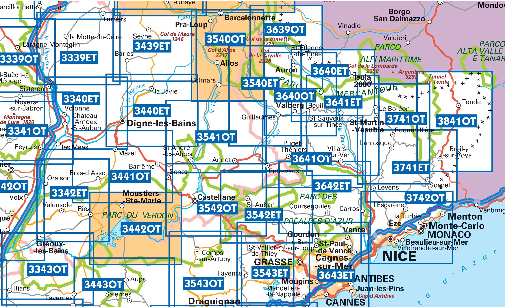
Topografische kaarten IGN 25.000 Mercantour - Noordelijke Provence


Producten op deze overzichtskaart:
Klik op een product om naar de pagina van dat product te gaan.
- Wandelkaart - Topografische kaart 3243OT Pertuis - Lourmarin | IGN - Institut Géographique National
- Wandelkaart - Topografische kaart 3339ET la Motte-du-Caire | IGN - Institut Géographique National
- Wandelkaart - Topografische kaart 3340ET Digne-les-Bains | IGN - Institut Géographique National
- Wandelkaart - Topografische kaart 3342ET Plateau de Valensole | IGN - Institut Géographique National
- Wandelkaart - Topografische kaart 3342OT Manosque - Forcalquier | IGN - Institut Géographique National
- Wandelkaart - Topografische kaart 3343OT Gréoux-les-Bains - Rians | IGN - Institut Géographique National
- Wandelkaart - Topografische kaart 3439ET Seyne | IGN - Institut Géographique National
- Topografische kaart - Wandelkaart 3440ET Digne-les-Bains | IGN - Institut Géographique National
- Wandelkaart - Topografische kaart 3441OT Barrême | IGN - Institut Géographique National
- Wandelkaart - Topografische kaart 3442OT Gorges du Verdon | IGN - Institut Géographique National
- Wandelkaart - Topografische kaart 3540ET Haute Vallée du Var | IGN - Institut Géographique National
- Wandelkaart - Topografische kaart 3540OT Barcelonnette | IGN - Institut Géographique National
- Wandelkaart - Topografische kaart 3541OT Annot | IGN - Institut Géographique National
- Wandelkaart - Topografische kaart 3542ET Haute Estéron | IGN - Institut Géographique National
- Wandelkaart - Topografische kaart 3542OT Castellane | IGN - Institut Géographique National
- Wandelkaart - Topografische kaart 3639OT Haute Tinée 1 | IGN - Institut Géographique National
- Wandelkaart - Topografische kaart 3640ET Haute Tinée 2 | IGN - Institut Géographique National
- Wandelkaart - Topografische kaart 3640OT Haut Cians | IGN - Institut Géographique National
- Wandelkaart - Topografische kaart 3641ET Moyenne Tinée | IGN - Institut Géographique National
- Wandelkaart - Topografische kaart 3641OT Moyen Var | IGN - Institut Géographique National
- Wandelkaart - Topografische kaart 3642ET Vallée de l'Esteron | IGN - Institut Géographique National
- Wandelkaart - Topografische kaart 3741ET Vallée de la Bévera | IGN - Institut Géographique National
- Wandelkaart - Topografische kaart 3741OT Vallée de la Vesubie | IGN - Institut Géographique National
- Wandelkaart - Topografische kaart 3841OT Vallée de la Roya | IGN - Institut Géographique National
-
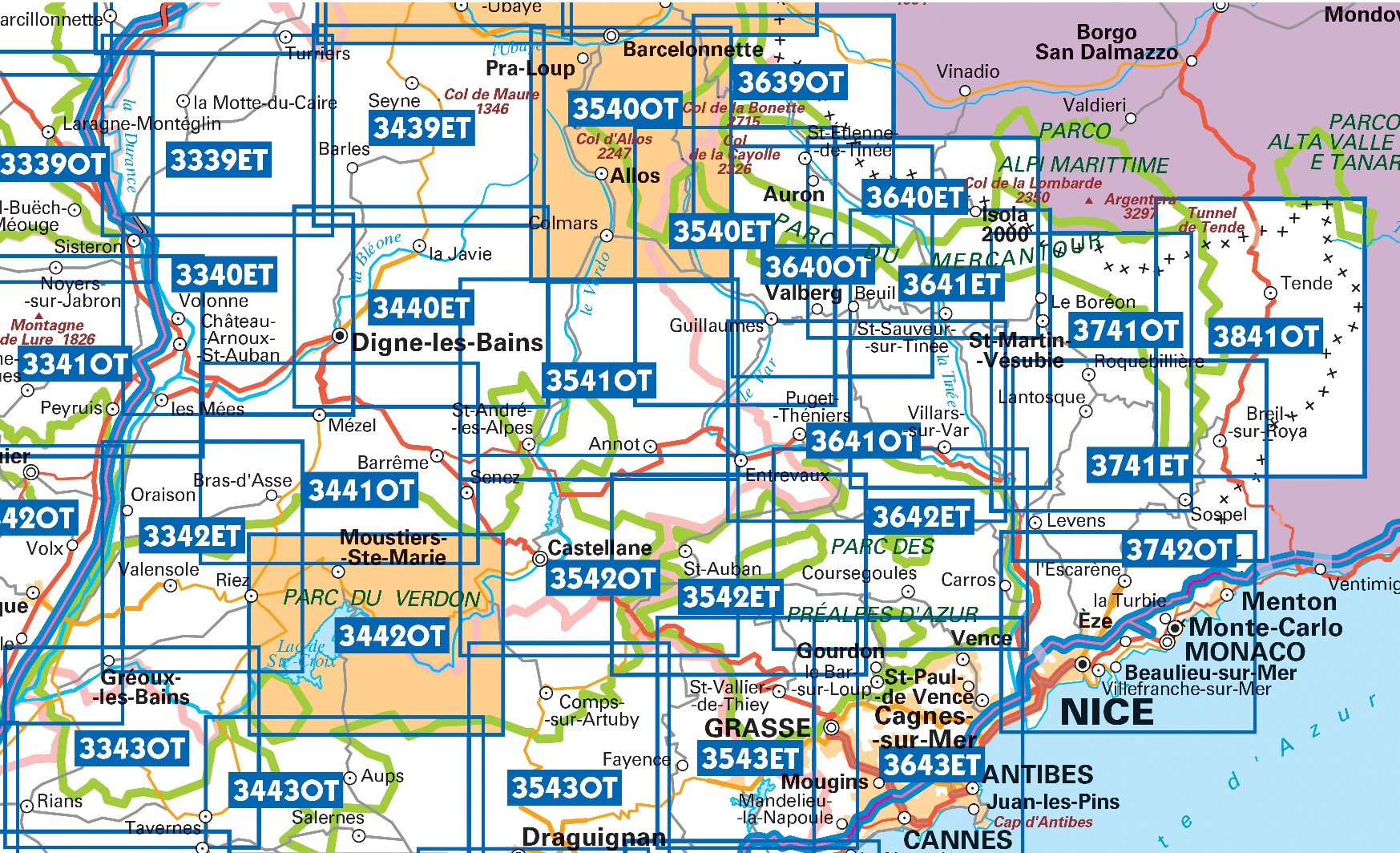
Wandelkaarten IGN 25.000 Mercantour - Noordelijke Provence


Producten op deze overzichtskaart:
Klik op een product om naar de pagina van dat product te gaan.
- Wandelkaart - Topografische kaart 3243OT Pertuis - Lourmarin | IGN - Institut Géographique National
- Wandelkaart - Topografische kaart 3339ET la Motte-du-Caire | IGN - Institut Géographique National
- Wandelkaart - Topografische kaart 3340ET Digne-les-Bains | IGN - Institut Géographique National
- Wandelkaart - Topografische kaart 3342ET Plateau de Valensole | IGN - Institut Géographique National
- Wandelkaart - Topografische kaart 3342OT Manosque - Forcalquier | IGN - Institut Géographique National
- Wandelkaart - Topografische kaart 3343OT Gréoux-les-Bains - Rians | IGN - Institut Géographique National
- Wandelkaart - Topografische kaart 3439ET Seyne | IGN - Institut Géographique National
- Topografische kaart - Wandelkaart 3440ET Digne-les-Bains | IGN - Institut Géographique National
- Wandelkaart - Topografische kaart 3441OT Barrême | IGN - Institut Géographique National
- Wandelkaart - Topografische kaart 3442OT Gorges du Verdon | IGN - Institut Géographique National
- Wandelkaart - Topografische kaart 3540ET Haute Vallée du Var | IGN - Institut Géographique National
- Wandelkaart - Topografische kaart 3540OT Barcelonnette | IGN - Institut Géographique National
- Wandelkaart - Topografische kaart 3541OT Annot | IGN - Institut Géographique National
- Wandelkaart - Topografische kaart 3542ET Haute Estéron | IGN - Institut Géographique National
- Wandelkaart - Topografische kaart 3542OT Castellane | IGN - Institut Géographique National
- Wandelkaart - Topografische kaart 3639OT Haute Tinée 1 | IGN - Institut Géographique National
- Wandelkaart - Topografische kaart 3640ET Haute Tinée 2 | IGN - Institut Géographique National
- Wandelkaart - Topografische kaart 3640OT Haut Cians | IGN - Institut Géographique National
- Wandelkaart - Topografische kaart 3641ET Moyenne Tinée | IGN - Institut Géographique National
- Wandelkaart - Topografische kaart 3641OT Moyen Var | IGN - Institut Géographique National
- Wandelkaart - Topografische kaart 3642ET Vallée de l'Esteron | IGN - Institut Géographique National
- Wandelkaart - Topografische kaart 3741ET Vallée de la Bévera | IGN - Institut Géographique National
- Wandelkaart - Topografische kaart 3741OT Vallée de la Vesubie | IGN - Institut Géographique National
- Wandelkaart - Topografische kaart 3841OT Vallée de la Roya | IGN - Institut Géographique National
Overzichtskaarten
Beschrijving
Reviews
Geen reviews gevonden voor dit product.
Schrijf een review
Graag horen wij wat u van dit artikel vindt. Vindt u het goed, leuk, mooi, slecht, lelijk, onbruikbaar of erg handig: schrijf gerust alles op! Het is niet alleen leuk om te doen maar u informeert andere klanten er ook nog mee!


